Weather
Thursday, 04 June 2026
84°F
Feels like: 83°
🌖
79%
Partly Cloudy
UV Index
0
Low
Measures the strength of UV radiation from the sun — the higher the value, the faster unprotected skin can be damaged. Max: 11+.
Air Quality Index
94
Moderate
Measures outdoor air pollution levels — higher values mean greater health risk, especially for sensitive groups. Max: 500.
Humidity
35%
Comfortable
Percentage of water vapor in the air. Low values feel dry and parched; high values feel muggy and oppressive. Max: 100%.
8 PM
82°
10 PM
73°
12 AM
68°
2 AM
65°
4 AM
63°
6 AM
62°
8 AM
65°
10 AM
75°
12 PM
82°
2 PM
85°
4 PM
86°
6 PM
85°
8 PM
82°
Tonight
Mostly clear, with a low around 62. South wind 0 to 5 mph.

Top Stories

- This is Ohio
- Ohio Supreme Court says people convicted of domestic violence can get guns back
- Mom of 2 working at Skyline Chili stabbed to death during shift by ex who had 'obsession' with her and was 'waving like he was proud' afterward: Cops
- Jon Husted admits Iran war's end 'not clear' after months of saying it would be 'brief and successful'
- Bill banning child marriage stalled in Ohio Senate
- Retired San Francisco firefighter dies from lung cancer after Blue Shield denies treatment claims
- Sherpa guide missing for a week on Mount Everest rescued while crawling to base camp
- Bondi Beach shooting hero Ahmed al Ahmed charged with assault
- Average US long-term mortgage rate falls to 6.48%, retreating from its highest level in 9 months
- Army’s plan for military death row executions is named ‘Operation Resolute Justice’
- Democrat fails to block US measure to deepen Israel military cooperation
- Ivory Coast beats France in World Cup warning to one of the favourites
- Democrats force vote on Trump’s $1.8bn settlement fund in ‘vote-a-rama’
- Kenyan president defends US Ebola facility amid deadly protests
- Why is the US so invested in Colombia’s election?
- Lululemon cuts annual outlook, citing 'negative' media commentary and disappointing product launches
- As the largest World Cup ever kicks off, health officials are focused on more than Ebola
- Soaring stocks created 2 million new millionaires around the world last year
- Why institutional investors are returning to retail 'in a very big way'
- Trump's 'big beautiful bill' has a 'double taxation' trap for top earners, tax experts say
- The lottery told me that my $100,000 win was actually a $20.00 misprint. They pulled the game hours later.
- A co-worker brought her puppy to work and I offered to watch him while she was in a meeting. Turns out he’s more vicious than I was expecting.
- The 'literary classics' that grade school makes you read destroys any desire for kids to read recreationally
- Police rage.
- Retired San Francisco firefighter dies from lung cancer after Blue Shield denies treatment claims
- GLP-1 drugs like Ozempic, Wegovy may help lower breast cancer risk by 30%
- Want to live longer? Study finds sweet spot for cardio and strength training
- How does rheumatoid arthritis affect conditions like depression, and vice versa?
- B12, folate supplements may be key to tackling chronic fatigue
- Combination therapy sustains 49% melanoma reduction after 5 years
- Ahead of its IPO, Anthropic’s Daniela Amodei shrugs off doubts about AI’s returns
- Airbnb’s Brian Chesky plans to launch a new AI lab
- Filtr is a new privacy tool that blocks ads in almost every iPhone and Mac app
- Defense tech, AI, and fundraising take center stage at StrictlyVC Los Angeles on June 18
- Startup Battlefield is returning to Australia — here’s what happened the last time we came to Sydney
- A study of 8,300 older adults revealed a surprising salt habit
- Goethe never knew this 40-million-year-old ant was hidden in his collection
- Scientists finally crack an “undruggable” pancreatic cancer target and nearly double survival
- Scientists discover vast hidden structure beneath Antarctica’s ice
- After 20 years, scientists finally shrink a powerful laser onto a chip
- Glittering star cluster image reveals missing patch of stars: 'We were not looking for the gap, but we found it'
- August 2026 lunar eclipse: Everything you need to know about the 96% 'blood moon'
- SpaceX launches back-to-back Starlink missions from both coasts 19 hours apart (photos)
- 12 of the weirdest 'Masters of the Universe' characters
- Most exoplanets might be 'soot factories,' scientists say: 'Like you have a natural diesel engine'
Weather Outlook
06/05 - Friday
Mostly sunny, with a high near 86. Southwest wind 2 to 14 mph, with gusts as high as 24 mph.
06/06 - Saturday
A slight chance of showers and thunderstorms between 7am and 8am, then showers and thunderstorms likely. Partly sunny, with a high near 87. Southwest wind 9 to 13 mph, with gusts as high as 23 mph. Chance of precipitation is 70%. New rainfall amounts less than a tenth of an inch possible.
06/07 - Sunday
A chance of showers and thunderstorms before 2pm, then a chance of showers and thunderstorms. Partly sunny, with a high near 87. Chance of precipitation is 40%. New rainfall amounts less than a tenth of an inch possible.
06/08 - Monday
A slight chance of showers and thunderstorms after 2pm. Mostly sunny, with a high near 89.
06/09 - Tuesday
A slight chance of rain showers between 8am and 2pm, then a slight chance of showers and thunderstorms. Partly sunny, with a high near 87.
06/10 - Wednesday
A slight chance of rain showers before 8am, then a chance of showers and thunderstorms between 8am and 2pm, then a chance of showers and thunderstorms. Partly sunny, with a high near 90. Chance of precipitation is 40%.
06/11 - Thursday
A slight chance of rain showers before 2pm, then a chance of showers and thunderstorms. Mostly sunny, with a high near 92.
Astronomy Picture of the Day
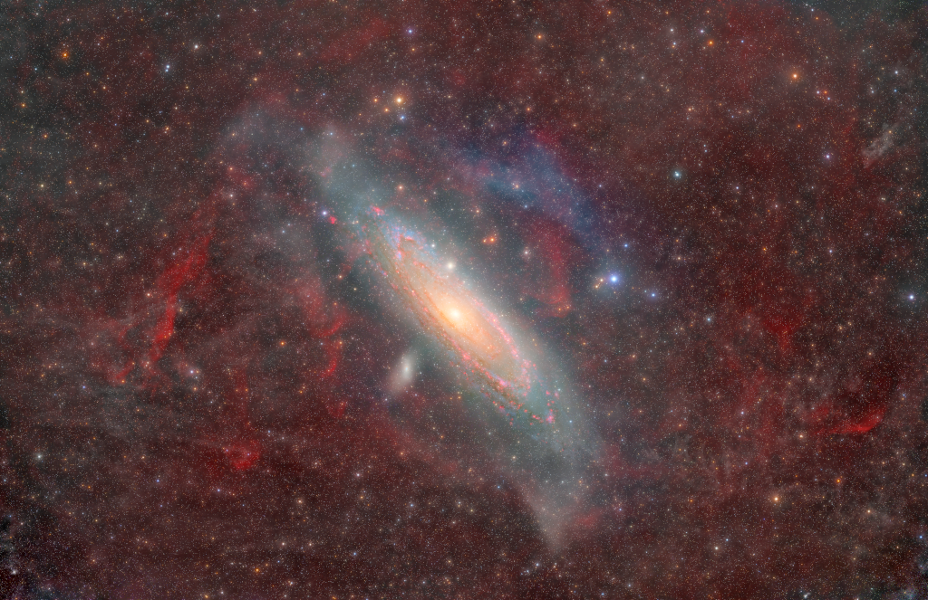
Andromeda Through Gas and Dust
Over 1000 years ago, Persian astronomer Abd al-Rahman al-Sufi published humanity’s oldest known record of the Andromeda Galaxy in "The Book of Fixed Stars" (Bodleian Library MS